
What California's '3 acres per 1,000' park test actually measures
California law has a definition of a park-poor neighborhood. Under the 2008 state park grant law (Pub. Res. Code §5642), one way to qualify as a "critically underserved community" is to have "less than three acres of usable parkland per 1,000 residents," and that helps decide who can apply to the State's park grant program. The test is short. Applying it involves a lot more choices than it lets on, starting with what counts as "usable parkland."
What counts as "usable parkland"
The law never defines it. The State's first draft grant guide, in December 2008, defined usable park space as parks open to the public, including parks that are temporarily closed. By 2019 the word "usable" had dropped out of the guidelines entirely. The current guide (Round 5, September 2026) defines a park as "open space land for the general public's physical and social HEALTH that provides at least one designated RECREATION FEATURE," and the State's FactFinder handbook spells out the test: outdoor open space, open to the public, with some recreation feature such as a trail, owned by any public agency. Undeveloped land counts if it's part of a public park, and so does forest or hillside land if a trail runs through it.
In practice, the State counts publicly owned parks and recreational open space whoever owns it: city, regional, state or federal. Around Berkeley, its data includes Tilden and the Tilden Nature Area, Claremont Canyon, Eastshore State Park, and even the UC Botanical Garden, which charges admission. Tilden's public golf course counts too. Schoolyards count when they have a joint-use agreement and signage identifying them for public recreation. When commenters argued in 2009 that nearby open space run by other agencies didn't meet local recreation needs, the State replied: "No change. Existing park space will count as existing park space."
Water counts too. The State's park data includes the water inside park boundaries: Lake Merritt, the bay inside Eastshore State Park, and the Aquatic Park lagoon, which is part of why the area around Aquatic Park scores so high. That's the same rule I applied when counting the lagoon in Berkeley's own numbers.
The published rules leave out cemeteries and permit-only nature preserves, and restrict which schoolyards count. The State's data also leaves out the Cal campus and UC's hill land and fire trails behind the stadium.
How it's measured
The grant test isn't applied citywide. The State measures a half-mile circle around the site of a proposed park project, counts only the park acreage inside that circle, and divides by the population living inside it. Population comes from Census estimates, spread across the circle by area. Applicants are allowed to move the pin within their site to get a better score.
What Berkeley looks like by the State's test
I ran the State's own tool, the Community FactFinder, on a grid of points across Berkeley.
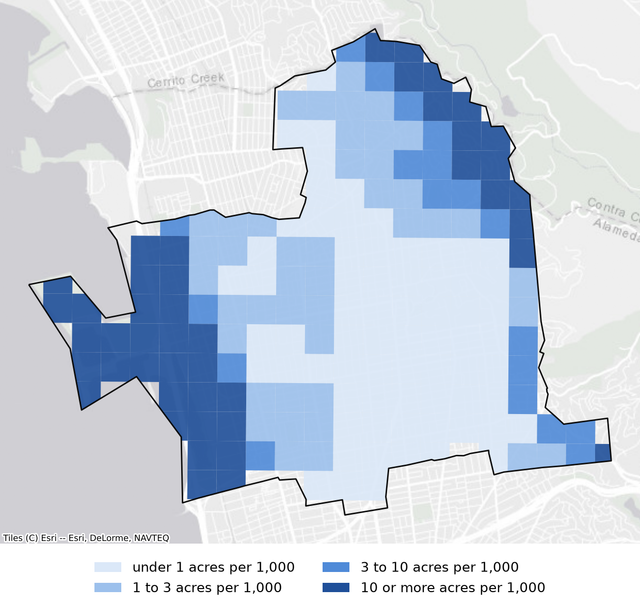
Source: the State's Community FactFinder, run at 176 points on a 400 m grid.
The pattern is stark. The waterfront, around Aquatic Park, Cesar Chavez Park and Eastshore, scores well above 10, and so does the hill edge along Tilden and Claremont Canyon. Almost everything in between is under 3, and most of inland central and south Berkeley is under 1. Of the 176 points I tested, 112, or 64%, fall under the 3-acre line.
| Location | Acres per 1,000 within a half mile |
|---|---|
| Aquatic Park | 106 |
| Dreamland playground | 40 |
| San Pablo Park | 1.4 |
| Ohlone Park | 1.1 |
| Elmwood | 0.7 |
| Downtown (Shattuck & Center) | 0.4 |
| Sacramento & Alcatraz | 0.2 |
| Euclid & Hearst | 0 |
What it means
By the State's definition, much of central and flatland Berkeley is "critically underserved." To me that defies common sense. A project can meet the program's need requirement in any of three ways: less than 3 acres per 1,000 within its half mile, a median household income below 80% of the state median, or proximity to a climate vulnerability the State has identified. The acreage route ignores income entirely, so a dense, affluent neighborhood qualifies on acreage alone, and it keeps qualifying no matter how wealthy it gets. Income does matter in scoring: in the current round, park acreage earns up to 15 points and poverty up to 13, each ranked against applicants statewide. But a wealthy, park-poor neighborhood still gets in the door and still scores well on acreage, which means it can compete for money meant for poorer communities that are genuinely short on parks.
A better test would pair acreage with income or access instead of letting acreage alone qualify a site.
Quirks in the data
The State's data is a grant-screening tool, not a precise inventory. People's Park, where UC is now building housing, is still counted as a park. A Berkeley school, John Muir, is attributed to a Southern California water agency. And because applicants can move the pin, the same project can score differently depending on where in the site it's placed.
Methods and sources
How I calculated it
- Definitions. From the State's Statewide Park Program application guides (2008, 2009, 2019 and Round 5 in 2026), the FactFinder handbook (June 2026), and FactFinder's methods and park data pages. The 2009 quote is from the State's responses to public comments on the program's criteria.
- Which lands count around Berkeley. The State's FactFinder park layer (October 30, 2026).
- Map. FactFinder's own results for 176 points on a 400-meter grid, collected November 8, 2026.
- Table. Separate FactFinder queries at the named locations, collected November 8, 2026.
Sources
- Statewide Park Program application guides (2008, 2009, 2019 and Round 5 in 2026), and the State's 2009 responses to public comments
- FactFinder handbook (June 2026)
- FactFinder methods and park data pages