
The Berkeley Pier and ferry: questions and answers before Tuesday's vote
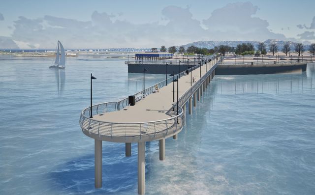
Rendering from the City's Draft EIR, Figure 2-4 (Robin Chiang & Company, 2026).
I'm the District 2 parks commissioner, but I am speaking in an individual capacity and not representing the Parks, Recreation and Waterfront Commission or the City of Berkeley.
On Tuesday, November 17, City Council votes on the Berkeley Pier-Ferry project. These are short answers to some of the most common questions, with links to the City's and WETA's own documents.
What is Council voting on?
The Council is voting on two things: certifying the project's environmental impact report (EIR), and approving the project and its use permit (Item 26 staff report). The vote doesn't commit any construction money. It will have no direct fiscal impact and, per the staff report, "does not commit the City to expenditure of construction funds."
What would be built?
A new 1,080-foot public pier where the old one stands (closed since 2015), a walkable breakwater about 300 feet long, and a terminal for electric ferries to San Francisco, about 25 minutes away. On land, the project adds a public plaza with a restroom, a Bay Trail segment, a rebuilt Seawall Drive and parking lot, shoreline erosion repair, and a raised bike lane and bigger bus stops on University Avenue. (Staff report)
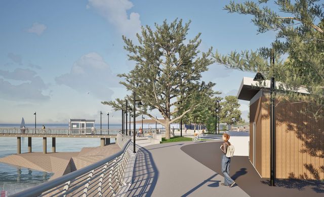
Rendering from the project's BCDC design review exhibits, November 2025. A little boring, but the City is still iterating on the design.
Why add a ferry? Why not just rebuild the pier?
The ferry is great, but this project is really about Berkeley working creatively with state and regional agencies to revitalize the marina and deliver a new pier for residents. The old pier can't be repaired anymore, and Berkeley doesn't have the money to replace it: the Marina Fund has run a structural deficit for more than 25 years, and in the City's worst-case projection its balance goes negative in 20271. City staff wrote in 2019 that funding for a pier "would be difficult to obtain for solely public recreation uses" (2019 staff report). A pier that also serves a ferry can draw on regional transportation money, starting with the $300 million that Regional Measure 3 bridge tolls set aside for ferry construction, and on state and regional grants for the landside work.
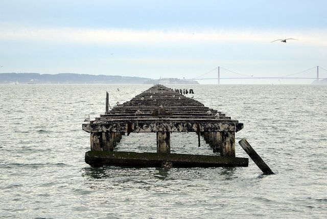
Photo: Amatulic, Wikimedia Commons, CC BY-SA 3.0.
How much will it cost?
The construction estimate is $139 million, escalated to a 2028 start and including contingency (staff report). That doesn't include the two electric boats, which WETA estimates at about $16 million each. About two-thirds of the cost is ferry infrastructure: the terminal, dredging, the breakwater, and charging2.
Who pays?
Under the 2019 agreement between the City and WETA, WETA pays for the ferry parts (including dredging), the City pays for the public-access parts, and they split anything both need (2019 agreement). Design and environmental review, about $11 million, is funded by a state Coastal Conservancy grant, a county transportation grant, and WETA. The City put $110,000 into the 2019–21 feasibility study (project update), and about $330,000 into an earlier study of pier options. Construction is expected to come "primarily through future grant awards from regional, state, and federal sources." The piece transit money won't cover is the recreational part of the pier past the breakwater, about 400 feet of it3.
Isn't it unfunded?
For construction, yes, and that's completely normal at this stage. Most construction grants require a certified environmental report, which is what Tuesday's vote provides. The City won't award construction contracts until the money is secured, and it can leave the WETA agreement at any time. Applications are starting: in September, City staff asked Council to authorize applying for up to $25 million in regional bridge-toll money for the landside work.
Will Berkeley pay to run the ferry?
No. WETA runs the ferry, paid for by fares and regional bridge tolls (tolls are about two-thirds of WETA's operating budget, per page 4 of its 2026-27 budget). The City's project update says "Berkeley is not required to subsidize WETA ferry operations." WETA's business plan projects an operating gap of about $4.3 million a year for the San Francisco route by year ten, which WETA covers (WETA business plan). This is public transit, and public transit is almost always subsidized, so an operating gap like this isn't unusual. You may have seen a claim that the ferry will need $9 million to $12 million a year, with Berkeley paying half. The number seems to come from a 2023 WETA planning memo, which estimated that range for a Berkeley–San Francisco route in its long-range 2050 scenarios, as money WETA would need to secure4. The idea that Berkeley pays half doesn't appear in any document I could find, and it contradicts the City's agreement with WETA, under which WETA pays all operating costs. The Berkeley-pays-half claim appears to be false. If Save Berkeley Pier believes otherwise, it should share the source document.
Isn't this a taxpayer-funded boondoggle?
You can reasonably argue about how much the Bay Area should spend on ferries. But that isn't Berkeley's decision. State lawmakers put Regional Measure 3 on the ballot, and Bay Area voters approved it in 2018. It set aside up to $300 million for ferry construction and up to $35 million a year for new ferry service (2021 staff report). That money is going to be spent on ferries somewhere. The money and the opportunity are there, and Berkeley should take advantage of them to get a new pier and a rebuilt waterfront.
Who would ride it?
WETA projects about 1,900 weekday boardings in the first year, with eight morning trips toward San Francisco on two boats, plus weekend service (WETA business plan).
Will the marina become a commuter parking lot?
No. The first-year plan sets aside 265 paid all-day spaces, 200 in the Seawall lot and 65 in the lot by Skates, and doesn't change the slip-holder lots, Spinnaker Way, Marina Boulevard, or University Avenue (parking plan). The City will adjust it as real demand shows up.
Can I fish on the new pier? Why is it shorter?
Yes. The City says all existing uses, "such as recreation, fishing, and parking, would continue," and the pier actually includes a fish cleaning station! (staff report). It's about a third the length of the old pier's public section, which was roughly 3,000 feet. But the old pier has been closed for eleven years and can't be repaired, so the choice in front of Council is 1,080 feet of open pier or none.
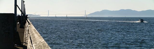
Photo: Benefactor123, Wikimedia Commons, CC BY-SA 3.0.
What happens on Seawall Drive?
About 33 of today's 84 spaces for viewing the Bay from your car stay. The rest of that edge becomes a Bay Trail segment, green space, benches, and picnic sites, and total parking along Seawall Drive and its lot stays about the same. People who like to watch the Bay from their cars do lose some spots, but in exchange we get more space for walking and recreation, which seems like a great trade to me. About 40 trees come out, mostly in poor health, and 50 to 70 are planted (Final EIR, section 2.2.24; Draft EIR).
Is it going to harm the Bay ecosystem?
Every significant impact the environmental report found that can't be fully mitigated comes from only one source: noise. That's pile driving during construction, for roughly 80 to 90 days, and the project's share of cumulative noise, from construction overlapping with other marina projects and from added traffic on University Avenue. Everything else is mitigated. Old pier pilings come out to offset the new structures, so there's no net increase in fill in the Bay, and the plan uses only electric boats. Dredging, up to 400,000 cubic yards for a channel along an existing federal one and a turning basin, is routine Bay work; the City just finished dredging the marina. The report estimates the project's operations cut about 2,368 metric tons of greenhouse gas emissions a year (staff report).
Why not put the ferry inside the marina?
The City considered it and rejected it, and the agency that would pay for it agrees. WETA, which would run the ferry and pay for the ferry parts, says a terminal inside the marina "is not considered operationally feasible" (Final EIR, section 2.2.12). Ferries would have to maneuver among recreational boats in a tight basin, docking and departures would take longer, each trip would grow by an estimated 5 to 10 minutes, and at least eight boat slips would be lost. A ferry terminal needs WETA's agreement and WETA's money, so this isn't something Berkeley can choose on its own.
Wouldn't it be way cheaper to put it in the marina?
There's no good reason to think so. The $20 million on the flyers comes from the Save Berkeley Pier campaign, which calls it a campaign estimate (Save Berkeley Pier). It has no breakdown and no apparent factual basis, and there's no current, credible cost estimate for a terminal inside the marina. If the campaign wants to show its math, I'd love to see it. And it's compared against $170 million, which covers the whole project, including the new pier and all the landside work.
By my own napkin math, using the City's line items, the savings aren't big5. A terminal inside the marina would still need the terminal itself, the dredging, and the charging. What it mostly skips is the breakwater, roughly $5 million to $7 million, and some of that would go to a separate walkway out to the ferry, since a terminal inside the marina can't share the new pier. And since the breakwater is mainly there for the ferry, much of that saving would likely be WETA's, not Berkeley's.
The real difference is who pays for the pier. Under the 2019 agreement, WETA pays for the ferry parts and shares the cost of anything both need, like the stretch of pier out to the terminal. Berkeley's clearest cost is the roughly 400 feet past the breakwater, about $4 million by my estimate. With the ferry inside the marina, the pier would be recreation-only, and WETA "can only fund and implement ferry projects" (Draft EIR, section 5.9). Berkeley would be back to finding construction money for the whole pier, about $11 million for the same length, which it hasn't managed since the old one closed in 2015.
Berkeley residents want the pier back. This plan gets us there.
Can't we just build the plaza and Bay Trail anyway?
Nothing stops the City from building them on its own, but there's no money identified for it. The landside work is designed around getting people to the ferry, and so is its funding. In September, City staff asked Council to authorize applying for up to $25 million in regional bridge-toll money for the landside work (September staff report), and that program only funds projects "connecting to rail transit stations and ferry terminals" (MTC guidelines). The City's list of potential Measure U projects also includes $5.25 million for Seawall Drive and the Bay Trail, as a match for a future grant. Without the ferry, the City would have to rethink how to pay for the landside work, since its current funding plan is built around the ferry, and the Marina Fund has run a structural deficit for 25 years.
Doesn't Measure L require a public vote?
Measure L, Berkeley's 1986 parks protection law, requires a vote when park or open space is used "for any other purpose than public parks and open space" (BMC 6.42.010). The new pier stays a public recreational pier, the landside work rebuilds an existing lot, plaza, and road and adds a Bay Trail segment, and the terminal sits in open Bay water. The Bay Plan from BCDC, the state's Bay permitting agency, also says ferry terminals "may be allowed in waterfront park priority use areas," as long as they don't interfere with park and recreational uses. It's still public open space and park use, it's still recreational, and no vote is needed. The City's Final EIR reaches the same conclusion (Final EIR, section 2.2.16)6.
When would it open?
That depends on construction funding. The City's parking plan puts ferry service at "early 2030, pending identification of construction funding" (parking plan).
What's still uncertain?
Construction funding has to be won. WETA's share of the pier hasn't been negotiated. The recreational pier extension needs its own funding. The City will have to maintain the new pier, plaza, and lot.
How can I weigh in?
The meeting is Tuesday, November 17, at 6 pm, in the School District Board Room at 1231 Addison Street, or on Zoom. The project is item 26, a public hearing (agenda). Written comments go to [email protected]. Please show up or call in to voice your support. As usual, a small number of very vocal opponents can be expected to show up to oppose any changes at the marina, and it's important that the Council hears from supportive Berkeley residents as well.
Photo credits: "Berkeley pier old part" by Amatulic and "Berkeley - Berkeley Pier 17" by Benefactor123, both CC BY-SA 3.0. Renderings are from the City's Draft EIR and the project's BCDC design review exhibits.


Notes
The waterfront's finances. The Marina Fund pays for most waterfront upkeep and has run a structural deficit for more than 25 years. The City's October 2025 projections show its balance going negative in fiscal 2027 if the DoubleTree hotel pays no rent, and staying positive in the scenarios where the hotel pays (Marina Fund update). As of 2024, the City listed $131 million in unfunded waterfront needs (Council, July 2024). A 2021 structural study priced repairing the old pier at $22 million to $65 million, and the project's engineers now say repair is no longer feasible (project update). ↩︎
The cost breakdown. The most detailed published breakdown is the City's October 2025 preliminary table, $103.6 million: ferry terminal $27.7 million, dredging $26.0 million, breakwater $6.8 million, electrification and utilities $5.6 million, pier $11.4 million, demolition $3.0 million, and landside work $23.1 million (parking lot, University Avenue, plaza, Seawall Drive, Bay Trail) (project update). It predates a planned shortening of the breakwater. The $139 million figure comes from a newer 2026 engineering estimate at 60% design, escalated to a spring 2028 start, with contingency and management costs added. WETA's boat estimate is from its 2022 business plan. ↩︎
The City's share. The 2019 agreement leaves the split of shared elements, like the stretch of pier out to the terminal, to be negotiated before construction. The recreational extension past the breakwater is the clearest City cost, since transit programs fund only transit. Measure U's project list includes $5.25 million for Seawall Drive and the Bay Trail to the pier as a match for a potential grant. ↩︎
The $9 million to $12 million figure. WETA's April 2023 memo to its board on the 2050 Service Vision lists a "Total Operating Subsidy" for Berkeley–San Francisco of $9.0 million to $12.1 million a year across four scenarios. It defines that as "the total amount needed to be secured by WETA" and calls the costs "preliminary and conceptual" (WETA memo, Table 14). In an October 2024 letter included in the Parks commission's packet, the founder of Save Berkeley Pier cited "WETA planning documents" for that range and said they "stated that Berkeley would be expected to pay half." I found no WETA document that says so. WETA's 2022 business plan for the Berkeley route projects a smaller year-ten gap: $4.3 million for San Francisco service, or $5.6 million with weekend service to Larkspur. Either way the gap is WETA's to cover: under the 2019 agreement WETA pays all operating costs of the service (2021 staff report), and bridge tolls supply 68% of WETA's operating revenue. ↩︎
Napkin math on the marina option. This is my own rough arithmetic from the City's October 2025 cost table (see the cost breakdown note), not an official estimate. Two questions matter: would the ferry parts cost less inside the marina, and who would pay for the pier?
The ferry parts. Wherever the terminal goes, it needs the terminal itself ($27.7 million), dredging ($26.0 million), and electrical work for charging ($5.6 million), about $59 million in all. Dredging doesn't go away inside the marina. The Final EIR says it would be "not significantly changed," because the boats still need a channel and room to turn outside the marina entrance (Final EIR, section 2.2.12). What the marina saves is the breakwater, since the basin is already sheltered: $6.8 million in the City's table, which priced a 400-foot breakwater, or roughly $5 million for the 300 feet Council is approving. Against that, a terminal inside the marina can't use the new pier, so it needs its own walkway out into the basin (WETA's 2008 design had a 522-foot one), plus moving docks and losing at least eight slips. None of those are priced.
The pier. The new pier costs $11.4 million. Roughly the first 675 feet lead to the breakwater and the ferry, which is where the environmental report's shorter-pier option would end, so WETA shares that part. The split hasn't been negotiated. The last 405 feet or so are purely for recreation, about $4.3 million at the same cost per foot. That's Berkeley's clearest cost today. With the ferry inside the marina, the whole pier would be Berkeley's: about $11.4 million for the same length, less for a shorter one.
So the ferry parts would cost about the same in either place, and the marina option would make the pier more expensive for Berkeley, not less. WETA's 2008 study points the same way: it priced a terminal inside the marina and one at the fishing pier within 5% of each other (2008 EIR/EIS). ↩︎
Measure L. Measure L's definition of open space is broad. It covers vacant public land "whether dedicated formally to park use or being used de facto as open space" (BMC 6.42.030), and land the City holds in trust (BMC 6.42.020), which I wrote about in the Allston Way post. So the question that matters is whether the project changes the use, and it doesn't. ↩︎